Size of this preview:
800 × 600 pixels. Other resolutions:
320 × 240 pixels |
640 × 480 pixels |
1,024 × 768 pixels |
1,280 × 960 pixels |
2,560 × 1,920 pixels |
4,032 × 3,024 pixels.
Original file (4,032 × 3,024 pixels, file size: 1.33 MB, MIME type: image/jpeg)
| This is a file from the
Wikimedia Commons. Information from its
description page there is shown below. Commons is a freely licensed media file repository. You can help. |
Summary
| Description |
中文:由位于中国湖北省武汉市的塔子湖体育中心改建的
方舱医院,用于集中收治轻度新型冠状病毒肺炎(COVID-19)患者。在武汉有16所类似的方舱医院,每家医院都可以容纳数百名轻度患者。在这些医院投入使用后,武汉的疫情有所缓解。
Français :
Hôpital Fangcang Réquisition et transformation du centre sportif de Tazi Lake en hôpital pour le traitement centralisé des personnes infectées par la « pneumonie de Wuhan » (lieu : avenue Houhu, district de Jiang'an, ville de Wuhan, province du Hubei en Chine continentale)
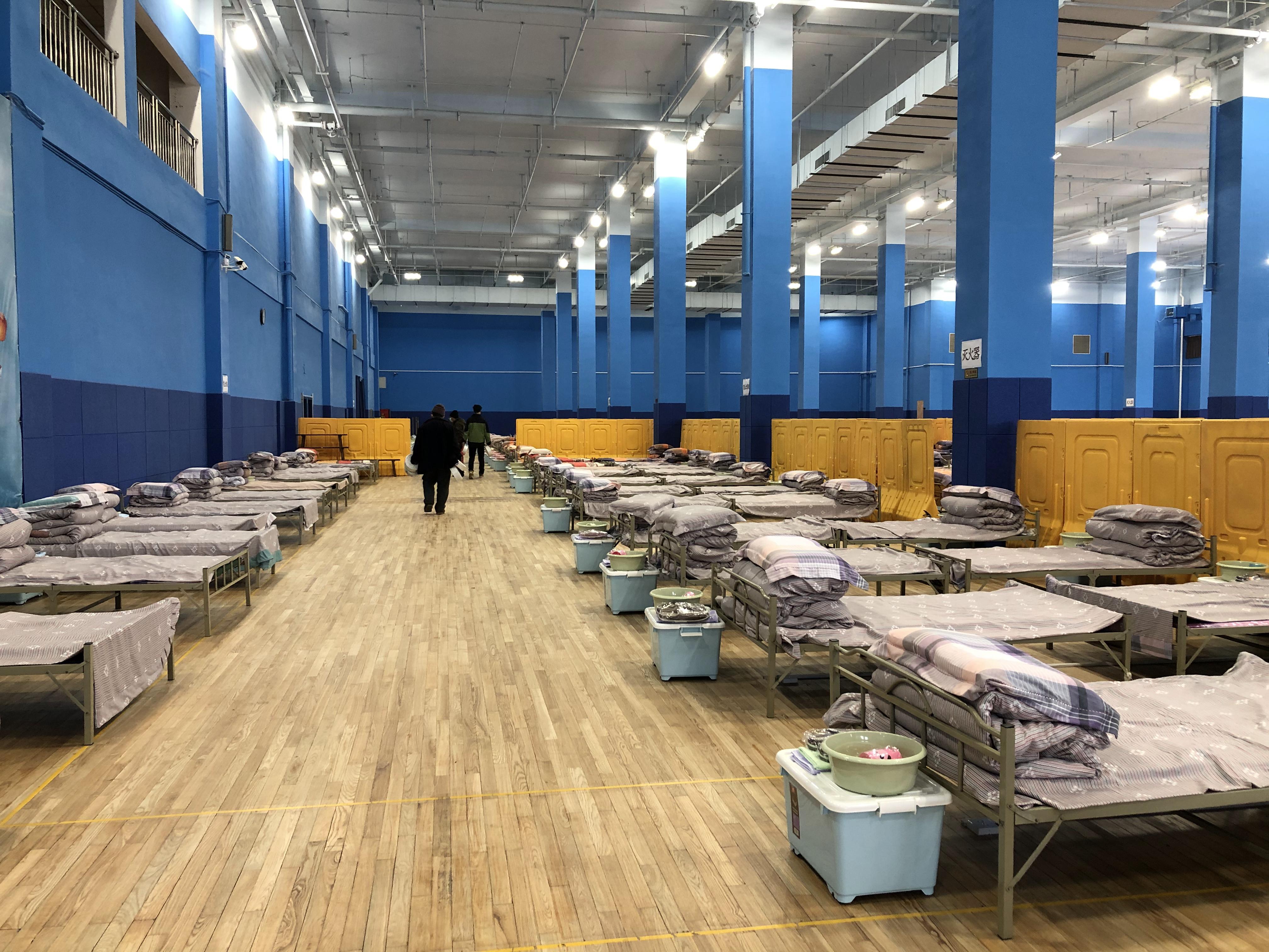
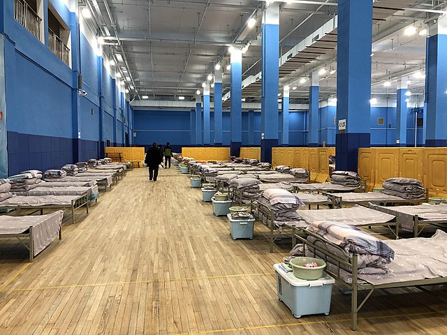
English: A
Fangcang hospital (makeshift hospital) in
Wuhan,
Hubei, China, which was converted from Tazihu Sports Center for treating mild COVID-19 patients. There were 16 Fangcang hospitals in Wuhan, and each of them could accommodate hundreds of mild patients. After these hospitals had come into use, the epidemic in Wuhan eased.
[1]
[2] |
| Date | |
| Source | Own work |
| Author | 汮汐 |
| Camera location | | View this and other nearby images on: OpenStreetMap |
|
|---|
References
- ↑ 郭超凯; 李亚南 (2020-02-06). “方舱医院”为何是武汉疫情防控的关键之举?. 中国新闻网.
- ↑ 方舱医院,中国制度的一个创举. 中国新闻网 (2020-03-09).
Licensing
I, the copyright holder of this work, hereby publish it under the following license:
This file is licensed under the
Creative Commons
Attribution-Share Alike 4.0 International license.
- You are free:
- to share – to copy, distribute and transmit the work
- to remix – to adapt the work
- Under the following conditions:
- attribution – You must give appropriate credit, provide a link to the license, and indicate if changes were made. You may do so in any reasonable manner, but not in any way that suggests the licensor endorses you or your use.
- share alike – If you remix, transform, or build upon the material, you must distribute your contributions under the same or compatible license as the original.
File history
Click on a date/time to view the file as it appeared at that time.
| Date/Time | Thumbnail | Dimensions | User | Comment | |
|---|---|---|---|---|---|
| current | 13:01, 11 February 2020 |
| 4,032 × 3,024 (1.33 MB) | 汮汐 | User created page with UploadWizard |
File usage
The following pages on the English Wikipedia use this file (pages on other projects are not listed):
Global file usage
The following other wikis use this file:
- Usage on ar.wikipedia.org
- Usage on ckb.wikipedia.org
- Usage on de.wikipedia.org
- Usage on en.wikiversity.org
- Usage on fr.wikipedia.org
- Usage on ht.wikipedia.org
- Usage on hu.wikipedia.org
- Usage on id.wikipedia.org
- Usage on lt.wikipedia.org
- Usage on ms.wikipedia.org
- Usage on oc.wikipedia.org
- Usage on pt.wikipedia.org
- Usage on ru.wikinews.org
- Usage on sr.wikipedia.org
- Usage on uk.wikipedia.org
- Usage on ur.wikipedia.org
- Usage on www.wikidata.org
- Usage on zh-yue.wikipedia.org
- Usage on zh.wikipedia.org