This article needs additional citations for
verification. (December 2009) |
Espírito Santo do Pinhal | |
|---|---|
| Municipality of Espírito Santo do Pinhal | |
| Nickname: Pinhal | |
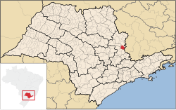
 Location in São Paulo | |
| Coordinates: 22°11′27″S 46°44′27″W / 22.19083°S 46.74083°W | |
| Country | |
| Region | Southeast |
| State | |
| Founded | December 27, 1849 |
| Government | |
| • Mayor | Sérgio del Bianchi Junior (2017 - 2020) ( PSD) |
| Area | |
| • Total | 389 km2 (150 sq mi) |
| Elevation | 870 m (2,850 ft) |
| Population (2020)
[1] | |
| • Total | 44,471 |
| • Density | 110/km2 (300/sq mi) |
| Time zone | UTC−3 ( BRT) |
| HDI (2010) | 0.787 – high [2] |
| Website |
www |
Espírito Santo do Pinhal ( Portuguese meaning "Holy Spirit of Pinhal") is a municipality in the state of São Paulo in Brazil. The population in 2020 is 44,471 (IBGE 2020) [3] and the area is 389 km2. The elevation is 870 m.
Notable people
References
- ^ IBGE 2020
-
^
"Archived copy" (PDF).
United Nations Development Programme (UNDP). Archived from
the original (PDF) on July 8, 2014. Retrieved August 1, 2013.
{{
cite web}}
: CS1 maint: archived copy as title ( link) - ^ "IBGE - @Cidades".
![]() Media related to
Espírito Santo do Pinhal at Wikimedia Commons
Media related to
Espírito Santo do Pinhal at Wikimedia Commons


