East Broadway | ||||||||||||||||||||||||||||||||||||||||||||||||||||||||||||||||||||||||||||||||||
|---|---|---|---|---|---|---|---|---|---|---|---|---|---|---|---|---|---|---|---|---|---|---|---|---|---|---|---|---|---|---|---|---|---|---|---|---|---|---|---|---|---|---|---|---|---|---|---|---|---|---|---|---|---|---|---|---|---|---|---|---|---|---|---|---|---|---|---|---|---|---|---|---|---|---|---|---|---|---|---|---|---|---|
|
| ||||||||||||||||||||||||||||||||||||||||||||||||||||||||||||||||||||||||||||||||||
 Northbound
R160 F train departs | ||||||||||||||||||||||||||||||||||||||||||||||||||||||||||||||||||||||||||||||||||
| Station statistics | ||||||||||||||||||||||||||||||||||||||||||||||||||||||||||||||||||||||||||||||||||
| Address | East Broadway & Rutgers Street New York, NY 10002 | |||||||||||||||||||||||||||||||||||||||||||||||||||||||||||||||||||||||||||||||||
| Borough | Manhattan | |||||||||||||||||||||||||||||||||||||||||||||||||||||||||||||||||||||||||||||||||
| Locale | Lower East Side | |||||||||||||||||||||||||||||||||||||||||||||||||||||||||||||||||||||||||||||||||
| Coordinates | 40°42′51″N 73°59′25″W / 40.714216°N 73.990259°W | |||||||||||||||||||||||||||||||||||||||||||||||||||||||||||||||||||||||||||||||||
| Division | B ( IND) [1] | |||||||||||||||||||||||||||||||||||||||||||||||||||||||||||||||||||||||||||||||||
| Line | IND Sixth Avenue Line | |||||||||||||||||||||||||||||||||||||||||||||||||||||||||||||||||||||||||||||||||
| Services |
F
| |||||||||||||||||||||||||||||||||||||||||||||||||||||||||||||||||||||||||||||||||
| Transit | ||||||||||||||||||||||||||||||||||||||||||||||||||||||||||||||||||||||||||||||||||
| Structure | Underground | |||||||||||||||||||||||||||||||||||||||||||||||||||||||||||||||||||||||||||||||||
| Platforms | 1 island platform | |||||||||||||||||||||||||||||||||||||||||||||||||||||||||||||||||||||||||||||||||
| Tracks | 2 | |||||||||||||||||||||||||||||||||||||||||||||||||||||||||||||||||||||||||||||||||
| Other information | ||||||||||||||||||||||||||||||||||||||||||||||||||||||||||||||||||||||||||||||||||
| Opened | January 1, 1936 | |||||||||||||||||||||||||||||||||||||||||||||||||||||||||||||||||||||||||||||||||
| Accessible | not ADA-accessible; accessibility planned | |||||||||||||||||||||||||||||||||||||||||||||||||||||||||||||||||||||||||||||||||
| Opposite- direction transfer | Yes | |||||||||||||||||||||||||||||||||||||||||||||||||||||||||||||||||||||||||||||||||
| Traffic | ||||||||||||||||||||||||||||||||||||||||||||||||||||||||||||||||||||||||||||||||||
| 2022 | 2,825,001
[3] | |||||||||||||||||||||||||||||||||||||||||||||||||||||||||||||||||||||||||||||||||
| Rank | 98 out of 423 [3] | |||||||||||||||||||||||||||||||||||||||||||||||||||||||||||||||||||||||||||||||||
| ||||||||||||||||||||||||||||||||||||||||||||||||||||||||||||||||||||||||||||||||||
| ||||||||||||||||||||||||||||||||||||||||||||||||||||||||||||||||||||||||||||||||||
| ||||||||||||||||||||||||||||||||||||||||||||||||||||||||||||||||||||||||||||||||||
| ||||||||||||||||||||||||||||||||||||||||||||||||||||||||||||||||||||||||||||||||||
| ||||||||||||||||||||||||||||||||||||||||||||||||||||||||||||||||||||||||||||||||||


The East Broadway station is a station on the IND Sixth Avenue Line of the New York City Subway. Located at East Broadway and Rutgers Street in the Lower East Side, it is served by the F train at all times and the <F> train during rush hours in the peak direction.
The East Broadway station was built for the Independent Subway System (IND)'s Sixth Avenue Line and opened on January 1, 1936. It contains one island platform and two tracks. The station was initially intended as an interchange station with the Worth Street Line underneath East Broadway, to be built as part of the IND Second System, although the other line was not completed. As a result, the station contains several mezzanines, one of which was originally intended as the platform level of the Worth Street Line. The station has exits to Rutgers Street's intersections with East Broadway and with Madison Street.
History
Construction and opening

New York City mayor John Francis Hylan's original plans for the Independent Subway System (IND), proposed in 1922, included building over 100 miles (160 km) of new lines and taking over nearly 100 miles (160 km) of existing lines, which would compete with the IRT and the Brooklyn–Manhattan Transit Corporation (BMT), the two major subway operators of the time. [4] [5] The IND Sixth Avenue Line was designed to replace the elevated IRT Sixth Avenue Line. [6] The first portion of the line to be constructed was then known as the Houston–Essex Street Line, which ran under Houston, Essex, and Rutgers Streets. The contract for the line was awarded to Corson Construction in January 1929, [7] and construction of this section officially started in May 1929. [8]
The East Broadway station opened on January 1, 1936, as the southern terminus of the first four stations to open on the Sixth Avenue Line. Two local tracks split from a junction with the Eighth Avenue Line south of West Fourth Street–Washington Square, running east under Houston Street and south under Essex Street to a temporary terminal at East Broadway. [9] The station was initially served by E trains to Church Avenue. [10] [11] Just after midnight on April 9, 1936, trains began running under the East River via the Rutgers Street Tunnel, which connected the Houston-Essex Street Line with the north end of the Culver Line at a junction with the Eighth Avenue Line north of Jay Street–Borough Hall. E trains were sent through the connection to Church Avenue. [10] [11] When further sections of the Sixth Avenue Line opened on December 15, 1940, the F train replaced the E train at the East Broadway station. [12]
Station renovation

In June 2018, improvements to the East Broadway station's exits were proposed as part of the development of the controversial 247 Cherry, 269 South Street, and 259 Clinton Street skyscrapers. The developers planned to create an entrance at the northeastern corner of Rutgers and Madison Streets by reusing part of the existing closed exit and creating a new street stair parallel to Madison Street from the passage. [13] In addition to a new exit, the developers planned to make the station compliant with the Americans with Disabilities Act of 1990 with the installation of elevators. [14] The plan was approved that December, [15] but the developments were blocked by a New York Supreme Court judge in February 2020, making the proposed improvements unlikely to occur. [16]
The Rutgers Street Tunnel was refurbished starting in late 2020. [17] [18] As part of the work, the East Broadway station's structural system was repaired and painted, while the platform edges, wall tiles, and stairs were replaced. Work was completed in February 2021. [19]
Station layout


| G | Street level | Exits/entrances |
| B1 | Mezzanine | Fare control, station agent |
| B2 | Mezzanine | Connection between fare control and platforms |
| B3 | Mezzanine [20] | Closed, used for maintenance |
| B4 Platform level |
Northbound | ←
|
| Island platform | ||
| Southbound |
| |
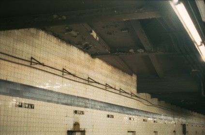
The station has one narrow, slightly curved island platform. There is an abandoned tower at the north end of the platform.
The tile band is medium Parma violet with a slightly darker border, set two tiles high. Tile captions below show the station name abbreviated as "E BWAY" in white letters on black. The I-beam columns are painted a similar shade of dark violet. The trackside walls showed a considerable pattern of aging and occasional water damage prior to the station's renovation, which replaced all the tiles and remained mostly faithful to the original design.
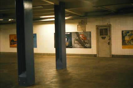
The 1992 artwork at this station is called Displacing Details by Noel Copeland, with assistance by students from the Henry Street Settlement.
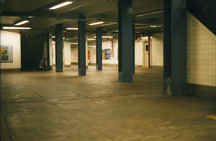
There are many closed sections at East Broadway, including restrooms that have been converted to office spaces. Inside fare control, the open intermediate level's mezzanine is split into two halves; the portion between the two halves was shuttered and is now used as maintenance space. Right below the open intermediate level is an entire closed intermediate level mezzanine, which is indicated by a brief intermediate level on staircases from the open mezzanine to the platform and now serves as storage space as well. [21] This closed mezzanine is accessible through fenced-off stairways at the either end of the station.
Unfinished station


The north half of the open intermediate level mezzanine was designed to eventually become a station of the unbuilt IND Worth Street Line. A locked door, located in the north end of the mezzanine, reveals additional closed platform space and an electrical room that hides the rest of the trackway and platform space. In this closed space, the platform floor drops to the level of the intended westbound trackway for the unbuilt line. [22]
The unused space runs for no more than 15 feet (4.6 m) before ending at a solid wall. Another door that leads to the electrical room hides the eastbound trackway. Near the north end of this station, a different ceiling structure angling across marks where the unbuilt subway would have gone. [23] The ramp that descends from the full-time side would have led to the same intermediate level, with a station facility in between, but that was never constructed. On the open intermediate level's mezzanine, the unusual spacing of some of the pillars marks where the line's platforms would have been placed. [24] [25]
Exits
The station has two mezzanines, four open staircases, three closed staircases, and one escalator. The full-time entrance at Madison Street has one street staircase, while the part-time entrance at Canal and Rutgers Streets has three. A passageway outside of fare control connects the two areas.
All exits to the station are street stairs. There is an exit to the northeastern corner of Canal Street and Essex Street, the western side of Rutgers Street between Canal Street and East Broadway, to the southeastern corner of East Broadway and Rutgers Street, and to the northwestern corner of Madison Street and Rutgers Street. [26]
In addition to the open entrances, there are two closed exits to the southwestern and northeastern corners of Henry Street and Rutgers Street that lead to the middle of the passageway outside fare control. There was also a short passage with a street stair parallel to Rutgers Street to the northeastern corner of Madison Street and Rutgers Street.
References
- ^ "Glossary". Second Avenue Subway Supplemental Draft Environmental Impact Statement (SDEIS) (PDF). Vol. 1. Metropolitan Transportation Authority. March 4, 2003. pp. 1–2. Archived from the original (PDF) on February 26, 2021. Retrieved January 1, 2021.
- ^ "Annual Subway Ridership (2017–2022)". Metropolitan Transportation Authority. 2022. Retrieved November 8, 2023.
- ^ a b "Annual Subway Ridership (2017–2022)". Metropolitan Transportation Authority. 2022. Retrieved November 8, 2023.
- ^ "Two Subway Routes Adopted by City". The New York Times. August 4, 1923. p. 9. ISSN 0362-4331. Archived from the original on June 30, 2019. Retrieved August 1, 2019.
- ^ "Plans Now Ready to Start Subways". The New York Times. March 12, 1924. p. 1. ISSN 0362-4331. Archived from the original on June 28, 2019. Retrieved August 1, 2019.
- ^ "Delaney For Razing Elevated Line Now; Work in 6th Av. Could Begin in Six Months if Condemnation Started at Once, He Says. Sees Cut In Subway Cost Eliminating Need for Underpinning Would Save $4,000,000 and Speed Construction, He Holds". The New York Times. January 11, 1930. ISSN 0362-4331. Archived from the original on April 28, 2018. Retrieved April 27, 2018.
- ^ "East Side Subway Will Evict 10,000; Work on New Line, Likely to Begin in May, Will Force Many Tenants to Move. 200 Buildings Will Fall Transportation Board Notifies Property Owners—Condemnation to Coat Over $11,000,000. Expect Work to Start in May. Residents Recall Other Days". The New York Times. February 24, 1929. ISSN 0362-4331. Archived from the original on May 6, 2022. Retrieved April 28, 2018.
- ^ "East Side Subway Started By Mayor; He Breaks Ground for Crosstown System at Second Av. and East Houston St. Miller Hails Project Sees Area Rejuvenated by Line and City's Plan to Raze Old Tenements". The New York Times. May 2, 1929. ISSN 0362-4331. Archived from the original on April 28, 2018. Retrieved April 28, 2018.
- ^ "LaGuardia Opens New Subway Link". The New York Times. January 2, 1936. p. 1. ISSN 0362-4331. Archived from the original on December 11, 2021. Retrieved October 7, 2011.
- ^ a b "Two Subway Links Start Wednesday". The New York Times. April 6, 1936. p. 23. ISSN 0362-4331. Archived from the original on June 14, 2018. Retrieved October 7, 2011.
- ^ a b "New Subway Link Opened by Mayor". The New York Times. April 9, 1936. p. 23. ISSN 0362-4331. Archived from the original on December 11, 2021. Retrieved October 7, 2011.
- ^ "The New Subway Routes". The New York Times. December 15, 1940. ISSN 0362-4331. Archived from the original on April 16, 2018. Retrieved April 15, 2018.
- ^ https://www1.nyc.gov/assets/planning/download/pdf/applicants/env-review/two-bridges/noc-feis.pdf Archived August 9, 2019, at the Wayback Machine page 45
- ^ Warerkar, Tanay (June 25, 2018). "Two Bridges skyscrapers to begin public review as locals, pols call for more time". Curbed NY. Archived from the original on December 19, 2018. Retrieved December 18, 2018.
- ^ "City Planning approves controversial trio of resi towers in Two Bridges". The Real Deal New York. December 5, 2018. Archived from the original on January 10, 2021. Retrieved December 18, 2018.
- ^ "A Second Ruling Against City's Approval of Two Bridges Skyscrapers". City Limits. February 25, 2020. Archived from the original on April 7, 2020. Retrieved May 24, 2020.
- ^ Hallum, Mark (December 8, 2020). "Rutgers Tube rehab on F line to enter final phase of completion Jan. 1: MTA". amNewYork. Archived from the original on May 13, 2022. Retrieved March 22, 2021.
- ^ McGoldrick, Meaghan (July 21, 2020). "Repairs to Hurricane Sandy-Damaged F Train Tunnel Will Start in August". Brownstoner. Archived from the original on August 20, 2020. Retrieved March 22, 2021.
- ^ "Capital Program Oversight Committee Meeting". Metropolitan Transportation Authority. March 17, 2021. Archived from the original on April 21, 2021. Retrieved March 22, 2021.
- ^ "East Broadway Mezzanine". LTV Squad. December 31, 2006.
- ^ "East Broadway Mezzanine". LTV Squad. December 31, 2006. Archived from the original on July 26, 2018. Retrieved September 15, 2016.
- ^ "Essex Street - East Broadway - the IND Second System". Archived from the original on March 4, 2016. Retrieved September 23, 2015.
-
^
https://web.archive.org/web/20100625185833/http://www.columbia.edu/~brennan/abandoned/EBway.ceil.jpg. Archived from
the original (JPG) on June 25, 2010.
{{
cite web}}
: Missing or empty|title=( help) -
^
http://www.columbia.edu/~brennan/abandoned/EBway.mezz2.jpg.
Archived from the original on April 24, 2013. Retrieved February 9, 2014.
{{
cite web}}
: Missing or empty|title=( help) -
^
http://www.columbia.edu/~brennan/abandoned/EBway.mezz1.jpg. Retrieved February 9, 2014.
{{
cite web}}
: Missing or empty|title=( help) - ^ "MTA Neighborhood Maps: Lower East Side" (PDF). Metropolitan Transportation Authority. 2015. Archived (PDF) from the original on July 24, 2015. Retrieved August 6, 2015.
External links
- nycsubway.org – IND 6th Avenue: East Broadway
- Station Reporter — F Train
- Abandoned Stations — IND Second System unfinished stations
- East Broadway entrance from Google Maps Street View
- Canal Street entrance from Google Maps Street View
- Madison Street entrance from Google Maps Street View
- Mezzanine from Google Maps Street View
- Platform from Google Maps Street View
|
Sixth Ave. Line |
| ||||||||||
|---|---|---|---|---|---|---|---|---|---|---|---|
| |||||||||||