| Detwiler Fire | |
|---|---|
 | |
| Date(s) |
|
| Location | Lake McClure, Mariposa County, California |
| Coordinates | 37°37′03″N 120°12′48″W / 37.61757°N 120.21321°W |
| Statistics [1] | |
| Burned area | 81,826 acres (331 km2) |
| Impacts | |
| Evacuated | ~4,000 |
| Structures destroyed | 131 structures (63 homes), 21 damaged |
| Ignition | |
| Cause | Firearm Discharge (Under further investigation) |
| Map | |
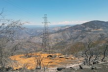
The Detwiler Fire was a wildfire that burned across Highway 49, east and south of Lake McClure, in Mariposa County, California. Ignited shortly before 4 p.m. on Sunday, July 16, 2017, the fire consumed up to 2,500 acres (1,000 ha) within its first day of burning. [2] By Thursday morning, on July 20, the fire was over 70,000 acres (28,000 ha) in size with only 7 percent containment. [1]
Progression
First reported at 3:56 p.m., the Detwiler fire was reported burning near Detwiler Road and Hunters Valley Road, 2 miles east of Lake McClure. [1] Within three hours, it had grown to over 1,000 acres as it spread primarily to the northeast. Mandatory evacuations were ordered for all homes along Detwiler Road, Hunters Valley Road, and Hunters Valley Access Road. [3] A Red Cross Evacuation Shelter was set up at McCay Hall, in Catheys Valley. [3] By nightfall, the fire was 2,500 acres in size with zero percent containment.
On the morning of Monday, July 17, the fire reached a reported 7,100 acres (2,900 ha) with still zero percent containment, as intense heat, windy conditions, and limited resources hampered suppression efforts. [4] Severe fire actively further lead to the evacuation of the Bear Valley area, south of the fire. Highway 49 was also closed due to the fire. [4]
A state of emergency was declared on Tuesday, July 18, 2017, as the fire exploded to over 25,000 acres (100 km2) within the day. The entire community of Mariposa was put under a mandatory evacuation order as over 5,000 structures were threatened. [5] Yosemite National Park remained open, however some access roads were closed and the fire caused smoky conditions throughout the park. [6]
By the morning of Friday, July 21, the fire had been reported at 74,083 acres at 15% containment. 118 structures had been reported destroyed, with 58 of those being homes. [1] As of 11:00 AM that day, the evacuation of Mariposa was lifted. [7]
Over the weekend of July 22 and 23, further evacuation orders were lifted for the surrounding affected areas and by July 24, the fire had burned 76,500 acres and was estimated at 50% containment. [1] Within the following days, fire crews had made significant headway, and by Wednesday, July 26, the fire was at 80,250 acres as containment had grown to 65% containment. [8]

By the evening of Friday, August 4, CAL FIRE reported the fire to be at 97% containment. [1] The cause of the fire was determined to be firearm-related, though specific details had not been released to the general public. [9]
On August 24, the fire was declared fully contained, after weeks of burning. [10]
Effects
By July 19, about 4,000 people were under evacuation orders. Close to 8,500 people lost power when the fire damaged power lines in the area. Yosemite National Park also lost power for several hours on July 18. [11]
References
- ^ a b c d e f "Detwiler Fire". CAL FIRE. Archived from the original on July 20, 2017. Retrieved July 16, 2017.
- ^ James, Cory. "Wildfire near Lake McClure forces evacuations in Mariposa County". ABC30 News. Archived from the original on 20 October 2017. Retrieved 16 July 2017.
- ^ a b Clugston, Gina (16 July 2017). "Wildfire Near Lake McClure Forces Evacuations". Sierra News Online. Archived from the original on 20 October 2017. Retrieved 16 July 2017.
- ^ a b Clugston, Gina (17 July 2017). "Evacuations Expand As Detwiler Fire Grows, Resources Stretched Thin". Sierra News Online. Archived from the original on 20 October 2017. Retrieved 17 July 2017.
- ^ Smith, Scott; Sonner, Scott (19 July 2017). "California wildfire near Yosemite threatens 5,000 homes; town evacuated". The Mercury News. Retrieved 19 July 2017.
- ^ Bacon, John. "Thousands flee flames roaring near Yosemite National Park". USA Today. Retrieved 19 July 2017.
- ^ "Detwiler Fire evacuation orders lifted for the town of Mariposa". ABC30 News. Retrieved 20 July 2017.
- ^ Hansen, B.J. (July 26, 2017). "Update: Detwiler Fire Acreage Slightly Increases, More Evacuation Orders Lifted". MyMotherLode.com. Retrieved July 26, 2017.
- ^ "Investigators have determined the cause of the Detwiler fire". ALLmercednews. August 4, 2017. Archived from the original on August 5, 2017. Retrieved August 4, 2017.
- ^ "Mariposa picking up the pieces after Detwiler Fire".
- ^ Rocha, Veronica; Bernhard, Meg (July 19, 2017). "Mariposa County fire doubles in size as flames force thousands to flee and threaten power to Yosemite". Los Angeles Times. Archived from the original on November 8, 2022. Retrieved November 28, 2023.
