| Daisetsuzan National Park | |
|---|---|
| 大雪山国立公園 | |
IUCN category II (
national park) | |

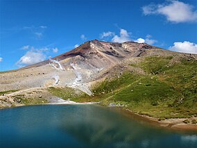
Mount Asahi, Daisetsuzan National Park. | |
| Location | Hokkaidō, Japan |
| Coordinates | 43°39′37″N 142°51′29″E / 43.660278°N 142.858056°E |
| Area | 2,267.64 km2 (875.54 sq mi) |
| Established | December 4, 1934 |
| Visitors | 6,000,000 [1] |
Daisetsuzan National Park (大雪山国立公園, Daisetsuzan Kokuritsu Kōen), or Taisetsuzan is located in the mountainous center of the northern Japanese island of Hokkaidō. At 2,267.64 square kilometres (875.54 sq mi), Daisetsuzan is the largest national park in Japan, and is approximately the size of Kanagawa Prefecture. Daisetsuzan, meaning "great snowy mountains", an apt description of these peaks. There are 16 peaks over 2,000 metres (6,600 ft) in Daisetsuzan National Park, both with and without trails. The park offers some of the most rugged scenery in Japan. Asahidake (2,290 metres (7,510 ft)), located in the north of the park, is the highest peak in Hokkaidō. Daisetsuzan National Park spans two subprefectures of Hokkaidō, Kamikawa and Tokachi. Daisetsuzan National Park was established in 1934. [2] [3] [4] [5] [6]
Mountain groups
Daisetsuzan National Park consists of three volcanic mountain groups. The groups consist of stratovolcanoes piled on top of each other. As one vent becomes active, it builds a peak then stops until a new vent appears. These groups are:
- Daisetsuzan Volcanic Group — lies in the northern part of the park and includes Hokkaidō's tallest mountain, Mount Asahi.
- Tokachi Volcanic Group — lies in the southwest of the park north of the Yubari and Hidaka Mountains. It includes Mount Tokachi [3]
- Shikaribetsu Volcanic Group — lies in the eastern part of the park and includes Mount Ishikari. The Ishikari River (268 kilometres (167 mi)), which emerges from Mount Ishikari, is the third longest in Japan and the longest in Hokkaidō. [7] [8]
These volcanic groups lie around a central highlands dominated by Mount Tomuraushi. The park is also known for its alpine meadows and remote backcountry.
Nature
Daisetsuzan National Park is famous for its wildlife, and the park is home to several rare species. [4] The park is notably home to a population of brown bears. The pika, a small mammal, with short limbs, rounded ears, and no external tail, is also found in the park. The forests of Daisetsuzan National Park are dominated by the Picea jezoensis, the Jezo spruce, and the Abies sachalinensis, the Sakhalin fir. [2] Of the 450 species of alpine plants found in Hokkaidō, half are found in Daisetsuzan National Park. [4]
Onsen
Daisetsuzan National Park also includes the onsen hot spring resorts of Asahidake Onsen, Fukiage Onsen, Sōunkyō Onsen and Tenninkyo Onsen.
See also
- List of national parks of Japan
- List of Special Places of Scenic Beauty, Special Historic Sites and Special Natural Monuments
References
- ^ Ehrlich, Gretel (August 2008). "Between Volcanoes". Nationional Geographic Magazine. National Geographic Society. p. 2. Archived from the original on July 19, 2008. Retrieved 2008-08-11.
- ^ a b "Daisetsuzan National Park". Encyclopedia of Japan. Tokyo: Shogakukan. 2012. OCLC 56431036. Archived from the original on August 25, 2007. Retrieved 2012-08-28.
- ^ a b "大雪山国立公園" [Daisetsuzan National Park]. Dijitaru Daijisen (in Japanese). Tokyo: Shogakukan. 2012. OCLC 56431036. Archived from the original on August 25, 2007. Retrieved 2012-08-28.
- ^ a b c "大雪山国立公園" [Daisetsuzan National Park]. Nihon Kokugo Daijiten (in Japanese). Tokyo: Shogakukan. 2012. OCLC 56431036. Archived from the original on August 25, 2007. Retrieved 2012-08-28.
- ^ "大雪山国立公園" [Daisetsuzan National Park]. Nihon Daihyakka Zensho (Nipponika) (in Japanese). Tokyo: Shogakukan. 2012. OCLC 153301537. Archived from the original on August 25, 2007. Retrieved 2012-08-28.
- ^ "大雪山国立公園" [Daisetsuzan National Park]. Nihon Rekishi Chimei Taikei (in Japanese). Tokyo: Shogakukan. 2012. OCLC 173191044. dlc 2009238904. Archived from the original on August 25, 2007. Retrieved 2012-08-28.
- ^ "Ishikarigawa". Encyclopedia of Japan. Tokyo: Shogakukan. 2012. OCLC 56431036. Archived from the original on August 25, 2007. Retrieved 2012-08-28.
- ^ 石狩川 [Ishikari River] (in Japanese). Tokyo: Ministry of Land, Infrastructure, Transport and Tourism. 2007. Archived from the original on 2009-04-01. Retrieved Aug 28, 2012.
External links
- Official Website of Daisetsuzan National Park
-
 Daisetsuzan National Park travel guide from Wikivoyage
 - Daisetsuzan National Park at Biodiversity Center of Japan, Ministry of the Environment
- Gretel Ehrlich: Daisetsuzan, National Geographic Magazine August 2008 link

