| Church Rock | |
|---|---|
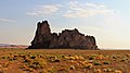
 Southwest aspect | |
| Highest point | |
| Elevation | 5,862 ft (1,787 m) NGVD 29 [1] |
| Prominence | 472 ft (144 m) [1] |
| Coordinates | 36°44′04″N 110°07′07″W / 36.7344445°N 110.1187371°W [2] |
| Geography | |
 Church Rock Location in Arizona  Church Rock Church Rock (the United States) | |
| Location | Navajo County, Arizona, U.S. |
| Topo map | USGS Church Rock |
| Geology | |
| Age of rock | Oligocene |
| Type of rock | Volcanic breccia |
Church Rock is a pillar in Navajo County, Arizona. It is located near the mouth of Church Rock Valley with a summit elevation of 5,862 feet (1,787 m). [1] It is situated 7.5 miles (12.1 km) east of the community of Kayenta, on Navajo Nation land, and can be seen from Highway 160 as it rises 400 feet above Church Rock Valley. It is one of the eroded volcanic plugs, or diatremes, of the Navajo Volcanic Field, which is a volcanic field that includes intrusions and flows of minette and other unusual igneous rocks which formed around 30 million years ago during the Oligocene. [3]
History
Church Rock was originally named Artenesales de Piedra or Sculpted Rock, by the Mexican merchant and explorer Antonio Armijo in 1829–1830, when the area was explored by his expedition to find a trade route between Santa Fe de Nuevo México and Alta California. This would become the Armijo Route of the Old Spanish Trail. [4] [5]
Gallery
-
 Southwest aspect
 -
 Southeast aspect
 -

-

-
-


.jpg)


.jpg)
Climate
Spring and fall are the most favorable seasons to visit Church Rock. According to the Köppen climate classification system, it is located in a semi-arid climate zone with cold winters and hot summers. Summers average 54 days above 90 °F (32 °C) annually, and highs rarely exceed 100 °F (38 °C). Summer nights are comfortably cool, and temperatures drop quickly after sunset. Winters are cold, but daytime highs are usually above freezing. Winter temperatures below 0 °F (−18 °C) are uncommon, though possible. This desert climate receives less than 10 inches (250 millimeters) of annual rainfall, and snowfall is generally light during the winter. [6]
References
- ^ a b c "Church Rock AZ". ListsOfJohn.com. Retrieved 2016-08-24.
- ^ "Church Rock". Geographic Names Information System. United States Geological Survey, United States Department of the Interior. Retrieved 2016-08-24.
- ^ Steven C. Semken, "The Navajo Volcanic Field", in Volcanology in New Mexico, New Mexico Museum of Natural History and Science Bulletin 18, p. 79, 2001. ISSN 1524-4156
- ^ Diario que formo yo el ciudando Antonio Armijo, como comandante, para el descubrimiento del camino para el punto de las Californias (Diary made by citizen Antonio Armijo as commandant for the discovery of the route to the Californias), Official Register of the Government the United States of Mexico, 1830, pp. 205–06
- ^ LeRoy R. Hafen and Antonio Armijo, Armijo's Journal,Huntington Library Quarterly, Vol. 11, No. 1 (Nov., 1947), pp. 87–101, University of California Press, doi: 10.2307/3816035
- ^ Climate Summary for Kayenta, Arizona
External links
![]() Media related to
Church Rock (Arizona) at Wikimedia Commons
Media related to
Church Rock (Arizona) at Wikimedia Commons