The neighborhood was created by Law 2022 of December 7, 1959.[1][2]
Population: 39,154 2010
Area: 228 hectares
Density: 162 hab/ha/km2
Number of housing units 17,254
History
The origins of the neighborhood are intertwined with the very formation of Porto Alegre. Its settlement began around 1732 when some families settled on the shores of
Lake Guaíba, where now is located the promenade
Rua da Praia. The settlers erected a tiny chapel dedicated to São Francisco das Chagas, in 1747, and around this chapel the first urbanization of the future Porto Alegre began to effectively organize itself.
In 1750, the governor of
Santa Catarina, Manoel Escudeiro de Souza, received orders to send to Porto do Viamão part of the couples who were about to arrive from the Azores to colonize the south of the country. In 1751, 60 families were selected, making a total of about 300 people, who arrived at the site in January 1752. At the time, an area of 141 hectares was delimited for the consolidation of the urban center, occupying the entire peninsula.
From then on, the small city began to be reorganized to fulfill its new role. In 1774 the War Arsenal, the first Mother Church and the Governor's Palace were built, and four years later fortifications were built on the perimeter opposite the lake. In the next two decades there were already several potteries in activity, indicating a growing building activity, shipyards were already building ships to order for
Rio de Janeiro, commerce in general was structured, and councilors were concerned with the beautification and cleaning of streets and public places . They also began to take shape in none of the oldest squares in Porto Alegre, such as
Praça XV, Praça da Matriz and Praça da Alfândega.
During the
Ragamuffin War, the center was surrounded by fortifications, but despite the population increase, the urban fabric would only grow again in 1845, with the end of the Revolution and the overthrow of the defense lines. The importance of the city's port for the circulation of people and goods throughout the Province grew accordingly, which would initiate a process of expansion of the city at the expense of the lake, with the construction of successive improvements and landfills on the coast. At the center, improvements were made to various public facilities, building fountains for water supply, modernizing public lighting, extending streets, creating new cemeteries, a new jail, nursing homes and a new Town Hall, a large opera house (Theatro São Pedro), expanding the Public Market and structuring medical care with two hospital complexes.
This acceleration, lasting until the mid-1930s, was known as the golden phase of Porto Alegre architecture, renewing the urban landscape according to the aesthetics of eclecticism, which, influenced by the prestigious German community, was quickly imitated by the elites for the construction of their new palaces. That was when some of the capital's most significant and luxurious public buildings were erected, some loaded with ethical, social and political symbolism, which were most conspicuously revealed in the allegorical decoration of the façades. Illustrative examples of this trend are the Piratini Palace, the Municipal Palace, the Public Library, the Bank of the Province, the Post Office and the Tax Office, most of them built in partnership between the architect Theodor Wiederspahn, the engineer Rudolf Ahrons and the decorator João Vicente Friedrichs, all of German origin. This urban evolution accompanied the emergence of a new bourgeois culture, stimulated by the influx of new migrants and immigrants, by the introduction of new technologies in the area of transport and engineering, and by the consolidation of a capitalist elite, which made sociability and urban spaces more complex, exclusive and diversified.
The 1950s were the heyday of the Center of Porto Alegre; it was already densely built and had Rua da Praia as the main catwalk for the elite, transformed from a wholesaler's point into an elegant shopping area, also attracting the installation of numerous cafes, patisseries, cinemas and restaurants. It has also become the preferred venue for popular gatherings at civic events and political demonstrations, sometimes witnessing scenes of collective violence. Thompson Flores, taking over City Hall in 1969, carried out a government characterized by major works, especially in the area of transport, favored by the economic boom of the
Brazilian Miracle. He built large viaducts, but the technical approach to the projects as a rule disregarded the popular will in prioritizing investments and elementary aspects of urban landscaping, and in this progressive zeal, numerous old buildings disappeared, some of great historical and architectural significance. The physiognomy of the center was impoverished.
Landmarks
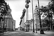
Praça da Matriz - Porto Alegre, RS, BrazilPraça da Matriz (Square Marechal Deodoro);
Starting and ending point: meeting of Loureiro da Silva Av. with João Goulart Av., on the promenade Luiz Celso Gomes Hyarup. From this point, follow João Goulart Av. along the shore of Lake Guaíba, skirting Ponta do Gasômetro, through Cais Mauá. From there, it follows a straight and imaginary line until the intersection of Castelo Branco Av. with Largo Vespasiano Júlio Veppo, to the Conceição Road Complex (tunnel, elevated, Conceição St.) until it merges into Sarmento Leite St. Finally, it follows that way to Luiz Englert St, Loureiro da Silva Av. and back to João Goulart Av., starting point.


.jpg)