Bekilli | |
|---|---|
District and
municipality | |
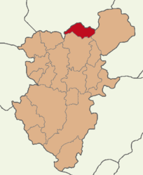
 Map showing Bekilli District in Denizli Province | |
| Coordinates: 38°13′55″N 29°25′18″E / 38.23194°N 29.42167°E | |
| Country | Turkey |
| Province | Denizli |
| Government | |
| • Mayor | Mustafa Çoban ( AKP) |
| Area | 304 km2 (117 sq mi) |
| Population (2022)
[1] | 6,424 |
| • Density | 21/km2 (55/sq mi) |
| Time zone | UTC+3 ( TRT) |
| Postal code | 20930 |
| Area code | 0258 |
| Website |
www |
Bekilli is a municipality and district of Denizli Province, Turkey. [2] Its area is 304 km2, [3] and its population is 6,424 (2022). [1] Bekilli district area neighbors the district areas of Çal and Çivril, both also depending Denizli to the west, south and east, and those of two districts of Uşak Province to the north, namely Ulubey and Karahallı.

The town of Bekilli is located in the inner Aegean region midway between the province seats of Denizli and Uşak, at a distance of 82 km (51 mi) from the first and 86 km (53 mi) from the second.
The town is renowned for its vineyards and celebrates an annual wine festival. Viticulture is a principal constituent of local culture.
Until the confirmation of its site slightly north of the town and south of the present-day neighboring district center of Karahallı, at a very short distance from Bekilli, the location of Bekilli was one of the leading candidates matched with ancient Pepuza (as well as its neighboring Tymion), associated with Montanism. Nevertheless, there are interesting and yet largely unexplored traces dating from Phrygian, Lydian, Roman and early Christian and Byzantine periods within Bekilli district area itself.
Composition
There are 15 neighbourhoods in Bekilli District: [4]
References
- ^ a b "Address-based population registration system (ADNKS) results dated 31 December 2022, Favorite Reports" (XLS). TÜİK. Retrieved 12 July 2023.
- ^ Büyükşehir İlçe Belediyesi, Turkey Civil Administration Departments Inventory. Retrieved 12 July 2023.
- ^ "İl ve İlçe Yüz ölçümleri". General Directorate of Mapping. Retrieved 12 July 2023.
- ^ Mahalle, Turkey Civil Administration Departments Inventory. Retrieved 12 July 2023.
External links


