Altair | |
|---|---|
Municipality | |
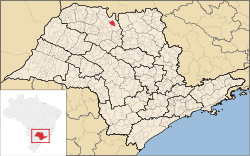
 Location in São Paulo state | |
| Coordinates: 20°31′27″S 49°3′34″W / 20.52417°S 49.05944°W | |
| Country | |
| Region | Southeast Brazil |
| State | São Paulo |
| Area | |
| • Total | 313.86 km2 (121.18 sq mi) |
| Population (2020
[1]) | |
| • Total | 4,186 |
| • Density | 13/km2 (35/sq mi) |
| Time zone | UTC−3 ( BRT) |
| Website |
www |
Altair is a municipality in the state of São Paulo in Brazil. The population is 4,186 (2020 est.) in an area of 313.86 km2. [2] The neighboring municipalities are Icém to the north and Olímpia to the east.
References
External links
- (in Portuguese) Official Site of Altair[ permanent dead link]
- (in Portuguese) citybrazil.com.br

