You can help expand this article with text translated from
the corresponding article in Finnish. (March 2009) Click [show] for important translation instructions.
|
Äänekoski | |
|---|---|
Town | |
| Äänekosken kaupunki Äänekoski stad | |
 Äänekoski town hall and library | |
 Coat of arms | |
 Location of Äänekoski in Finland | |
| Coordinates: 62°36′N 025°43.5′E / 62.600°N 25.7250°E | |
| Country | |
| Region | Central Finland |
| Sub-region | Äänekoski sub-region |
| Charter | 1932 |
| City rights | 1973 |
| Government | |
| • Town manager | Matti Tuononen |
| Area (2018-01-01)
[1] | |
| • Total | 1,138.39 km2 (439.53 sq mi) |
| • Land | 884.61 km2 (341.55 sq mi) |
| • Water | 253.84 km2 (98.01 sq mi) |
| • Rank | 87th largest in Finland |
| Population (2023-12-31)
[2] | |
| • Total | 17,977 |
| • Rank | 64th largest in Finland |
| • Density | 20.32/km2 (52.6/sq mi) |
| Population by native language | |
| • Finnish | 98% (official) |
| • Swedish | 0.1% |
| • Others | 1.8% |
| Population by age | |
| • 0 to 14 | 15.2% |
| • 15 to 64 | 56.8% |
| • 65 or older | 27.9% |
| Time zone | UTC+02:00 ( EET) |
| • Summer ( DST) | UTC+03:00 ( EEST) |
| Website |
www |
Äänekoski (Finnish pronunciation: [ˈæːneˌkːoski]) is a town in Finland. It is located in the Central Finland region, about 45 kilometres (28 mi) north of Jyväskylä. The town has a population of 17,977 (31 December 2023) [6] and covers an area of 1,138.39 square kilometres (439.53 sq mi) of which 253.84 km2 (98.01 sq mi) is water. [1] The population density is 20.32 inhabitants per square kilometre (52.6/sq mi).
Neighbouring municipalities are Kannonkoski, Konnevesi, Laukaa, Saarijärvi, Uurainen, Vesanto and Viitasaari.
The municipality is unilingually Finnish. [3]
The municipality of Äänekosken maalaiskunta was consolidated to Äänekoski in 1969 and the municipality of Konginkangas in 1993. The municipalities of Sumiainen and Suolahti were consolidated to Äänekoski in 2007.
History

Äänekoski is named after the nearby rapids. Folk etymology connects the name to the word ääni "sound", but Terho Itkonen has suggested another origin: a Sámi term meaning "big, large" (compare Northern Sámi eanas, "most").
Swedish sources mention a salmon fishery by the rapids around 1455, Ænækoski laxefiskeri. At the time, it was not a proper settlement and was located in the hunting grounds of the people of Sysmä. The Rautalampi parish was established in 1561, at the time it was a large parish covering most of Central Finland north of the Päijänne. The Laukaa parish, including the area of Äänekoski, was separated from Rautalampi in 1628.
A settlement named Äänekoski has existed at least since 1752. It remained a part of Laukaa until the parish was established in 1907 and the municipality Äänekosken maalaiskunta was established in 1911. At the time, Äänekosken maalaiskunta was called simply Äänekoski. The municipality was divided in 1932: the actual settlement of Äänekoski became the kauppala of Äänekoski, Suolahti became another kauppala while the old Äänekoski municipality was renamed Äänekosken maalaiskunta and its administrative seat was moved to the village of Honkola. Äänekoski and Äänekosken maalaiskunta still shared a parish. [7]
The first industrial enterprises appeared in 1896–1900.
Four municipalities have been consolidated with Äänekoski: Äänekosken maalaiskunta in 1969, Konginkangas in 1993 and Sumiainen and Suolahti in 2007. Äänekoski adopted the coat of arms of Suolahti in 2007.
Geography

Äänekoski is located along Finnish national road 4 approximately 40 km north of Jyväskylä. Finnish national road 69 to Suonenjoki begins in Hirvaskangas, 12 km south of Äänekoski center. Finnish national road 13 between Kokkola and Lappeenranta passes through Honkola, 6 km south of Äänekoski center. Äänekoski center is located between the Ääneselkä open water part of Lake Keitele and Lake Kuhnamo.
Villages
Modern Äänekoski is a product of a merger of multiple former municipalities, where the following villages were officially named:
- Konginkangas: Kalaniemi, Konginkangas center, Pyyrinlahti [8]
- Sumiainen: Paadentaipale, Raikkaus, Sumiaisten kirkonkylä (Sumiainen church village) [9]
- Suolahti: Suolahti center
- Äänekoski ja Äänekosken maalaiskunta (Rural Municipality of Äänekoski): Äänekoski center, Honkola, Kangashäkki (main part of which is in Uurainen), Kiimasjärvi, Koivisto (Koivistonkylä) and Petruma. [10]
Besides these official divisions, the following villages or neighborhoods are also informally recognized: Hietama, Hirvaskangas, Laajaranta, Liimattala, Mämme, Parantala ja Rannankylä.
Nature
The area is heavily forested. It is also defined by the fractured Lake Keitele, which stretches generally in the southwest-northeast direction from Äänekoski center to the open waters of Keitele proper in Havusalmi, but which has multiple bays in the perpendicular, southeast-northwest direction.
There are 13 Natura 2000 protected areas in Äänekoski. These include esker areas, waters rich in bird life and part of the Hitonhauta-Kylmähauta-Hirvasjoki ravine area, which extends from Äänekoski to Laukaa. [11] [12]
There are altogether 170 lakes in Äänekoski. The biggest lakes are Keitele, Kuhnamo and Niinivesi. [13]
One of the world's smallest rivers, the Kuokanjoki, is within the area. [14] Aatunselkä is also located in this area. [15]
Demographics
In 2021, there were 18,318 inhabitants, of which 75.8% lived in urban areas. There are three urban areas: Äänekoski center (12,899 inhabitants), Konginkangas (445) and Sumiaisten kirkonkylä (church village of Sumiainen, 406). Suolahden keskustaajama (the center of Suolahti), Kierälahti and Paatela used to categorized as a separate urban areas, but they are now counted as a part of Äänekoski center.
Economy
Äänekoski is a major industrial center. The largest corporate tax payer is Valtra, a manufacturer of tractors and agricultural machinery, which is a part of AGCO Corporation, followed by Kurikka Timber, a manufacturer of window components. Aura cheese is manufactured in the Valio's Äänekoski dairy. The forest, pulp and paper industry is a major employer. In 1891, a groundwood pulp mill and a cardboard factory was founded in Äänekoski. Currently, sites in Äänekoski include a Metsä Board folding boxboard factory, Metsä Fibre kraft pulp and bioproduct mill, Metsä Wood plywood factory (former Finnforest) and a Nouryon plant (former CP Kelco), which manufactures chemical derivatives of cellulose.
Twin towns – sister cities
The following cities or municipalities are twinned with Äänekoski: [16]
-
 Örnsköldsvik Municipality, Sweden
 -
 Brande,
Brande Municipality, Denmark
Brande,
Brande Municipality, Denmark -
 Sigdal, Norway
 -
 Alushta,
Alushta municipality, Ukraine
Alushta,
Alushta municipality, Ukraine -
 Borovichi,
Novgorod Oblast, Russia (status unknown)
Borovichi,
Novgorod Oblast, Russia (status unknown) -
Sestroretsk, Russia
-
 Niamey, Niger
Gallery
-
 A porter locomotive of the Äänekoski-Suolahti narrow gauge railway
 -
 A freight train departing from a pulp mill in Äänekoski
 -
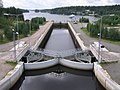 Kapeenkoski Lock of Keitele–Päijänne canal.
 -
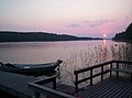 A sunset at Lake Keitele


See also
- Aura cheese – a blue cheese produced in Äänekoski
- Finnish national road 69
References
- ^ a b "Area of Finnish Municipalities 1.1.2018" (PDF). National Land Survey of Finland. Retrieved 30 January 2018.
- ^ "Immigration record high in Finland in 2023". StatFin. Statistics Finland. Retrieved 25 January 2024.
- ^ a b "Demographic Structure by area as of 31 December 2022". Statistics Finland's PX-Web databases. Statistics Finland. Retrieved 6 September 2023.
- ^ "Population according to age (1-year) and sex by area and the regional division of each statistical reference year, 2003–2020". StatFin. Statistics Finland. Retrieved 2 May 2021.
- ^ a b "Luettelo kuntien ja seurakuntien tuloveroprosenteista vuonna 2023". Tax Administration of Finland. 14 November 2022. Retrieved 7 May 2023.
- ^ "Population by municipality as of 31 December 2006". Population Information System (in Finnish and Swedish). Population Register Center of Finland. Retrieved 2 May 2010.[ permanent dead link]
- ^ "SuomalainenPaikannimikirja_e-kirja_kuvallinen.pdf" (PDF). kaino.kotus.fi (in Finnish). p. 531. Retrieved 23 August 2022.
- ^ Tarmio, Hannu; Papunen, Pentti ja Korpela, Kalevi (ed.). Suomenmaa: maantieteellis-yhteiskunnallinen tieto- ja hakuteos. 4, Kokkola – Lestijärvi, p. 17, WSOY, Porvoo 1971.
- ^ Suomenmaa 7 (1978): s. 160
- ^ Suomenmaa 7 (1978): s. 500
- ^ https://www.ymparisto.fi/fi-FI/Luonto/Suojelualueet/Natura_2000_alueet?f=KeskiSuomen_ELYkeskus
- ^ https://www.ymparisto.fi/fi/luonto-vesistot-ja-meri/luonnon-monimuotoisuus/suojelu-ennallistaminen-ja-luonnonhoito/natura-2000-alueet/hitonhauta-kylmahauta-hirvasjoki
- ^ "Äänekoski". Järviwiki. Finland's Environmental Administration. 2012. Retrieved 27 February 2012.
- ^ "Sumiaisten kyläyhdistys". sumiainen.fi. Retrieved 11 April 2022.
- ^ "Aatunselkä (14.332.1.007)". Järvi-meriwiki (in Finnish). 1 February 2011. Retrieved 7 October 2023.
- ^ "Äänekosken kaupungin ystävyyskuntatoiminnan edistäminen" (in Norwegian). City of Äänekoski. Archived from the original on 19 July 2012. Retrieved 1 June 2012.
External links
![]() Media related to
Äänekoski at Wikimedia Commons
Media related to
Äänekoski at Wikimedia Commons
- Town of Äänekoski – Official website (in Finnish)
Places adjacent to Äänekoski | ||||||||||||||||
|---|---|---|---|---|---|---|---|---|---|---|---|---|---|---|---|---|
| ||||||||||||||||
| Municipalities | ||
|---|---|---|
| Former municipalities | ||
| International | |
|---|---|
| National | |
| Geographic | |