
Size of this preview:
609 × 599 pixels. Other resolutions:
244 × 240 pixels |
488 × 480 pixels |
781 × 768 pixels |
1,041 × 1,024 pixels |
2,082 × 2,048 pixels |
2,977 × 2,929 pixels.
Original file (2,977 × 2,929 pixels, file size: 2.14 MB, MIME type: image/png)
| This is a file from the
Wikimedia Commons. Information from its
description page there is shown below. Commons is a freely licensed media file repository. You can help. |

_and_the_Crown_of_the_Kingdom_of_Poland_(red)_in_1386_-_1434.png)

|
This historical map image could be re-created using
vector graphics as an
SVG file. This has several advantages; see
Commons:Media for cleanup for more information. If an SVG form of this image is available, please upload it and afterwards replace this template with
{{
vector version available|new image name}}
.
It is recommended to name the SVG file “Map of the Grand Duchy of Lithuania (pink) and the Crown of the Kingdom of Poland (red) in 1386 - 1434.svg”—then the template Vector version available (or Vva) does not need the new image name parameter. |
Summary
| Description |
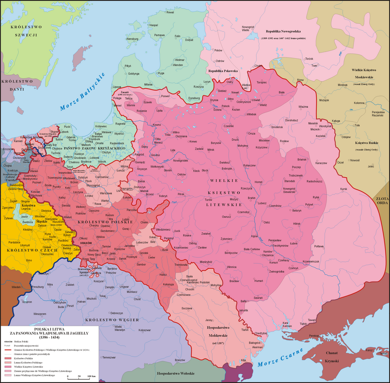
English: Map of the
Grand Duchy of Lithuania (pink) and the
Crown of the Kingdom of Poland (red) under the reign of
Władysław II Jagiełło (Jogaila) in 1386 - 1434.
Polski: Mapa Polski i Litwy za panowania Władysława II Jagiełły (1386 - 1434).
Lietuvių: Lietuvos Didžiosios Kunigaikštystės (rožinė) ir Lenkijos Karalystės Karūnos (raudona) žemėlapis valdant
Jogailai 1386 - 1434 m. |
| Date | |
| Source | Own work based on: Sienkiewicz, Witold (2006) (in Polish) Ilustrowany atlas historii Polski, Warsaw: Demart ISBN: 9788374272179. OCLC: 838949217. |
| Author | Poznaniak |
| Permission ( Reusing this file) |
I, the copyright holder of this work, hereby publish it under the following license: This file is licensed under the
Creative Commons
Attribution-Share Alike 3.0 Unported license.
|
File history
Click on a date/time to view the file as it appeared at that time.
_and_the_Crown_of_the_Kingdom_of_Poland_(red)_in_1386_-_1434.png&dir=prev)
_and_the_Crown_of_the_Kingdom_of_Poland_(red)_in_1386_-_1434.png&offset=20100220202203)
_and_the_Crown_of_the_Kingdom_of_Poland_(red)_in_1386_-_1434.png&offset=&limit=20)
_and_the_Crown_of_the_Kingdom_of_Poland_(red)_in_1386_-_1434.png&offset=&limit=50)
_and_the_Crown_of_the_Kingdom_of_Poland_(red)_in_1386_-_1434.png&offset=&limit=100)
_and_the_Crown_of_the_Kingdom_of_Poland_(red)_in_1386_-_1434.png&offset=&limit=250)
_and_the_Crown_of_the_Kingdom_of_Poland_(red)_in_1386_-_1434.png&offset=&limit=500)
| Date/Time | Thumbnail | Dimensions | User | Comment | |
|---|---|---|---|---|---|
| current | 18:34, 12 May 2016 |
| 2,977 × 2,929 (2.14 MB) | Poznaniak | Rewert po wandalu |
| 17:32, 10 May 2016 |
 | 2,977 × 2,929 (2.17 MB) | Julieta39 | Same map without mistakes : read please the explanations on the discussion page. | |
| 12:46, 16 August 2013 |
 | 2,977 × 2,929 (2.14 MB) | Poznaniak | Rewert - Mołdawia była lennem i tak też jest zaznaczona | |
| 09:42, 16 August 2013 |
 | 2,977 × 2,929 (2.14 MB) | Spiridon Ion Cepleanu | Little changes: Moldavia was a vassal (1387-1497), not a part of Polish kingdom; Kilia was on the south side of Chilia arm (Danube delta was moldavian till 1484); Akkerman is the turkish name (1484) of Bialgorod. | |
| 12:48, 24 February 2013 |
 | 2,977 × 2,929 (2.14 MB) | Poznaniak | popr. | |
| 19:50, 23 February 2013 |
 | 2,977 × 2,929 (2.14 MB) | Poznaniak | popr. | |
| 16:19, 23 February 2013 |
 | 2,977 × 2,929 (2.13 MB) | Poznaniak | popr. | |
| 10:54, 1 January 2012 |
 | 2,977 × 2,930 (1.61 MB) | Poznaniak | Reverted to version as of 20:22, 20 February 2010 | |
| 17:41, 31 December 2011 |
 | 2,963 × 2,916 (1.35 MB) | Ras67 | cropped and optimized | |
| 20:22, 20 February 2010 |
 | 2,977 × 2,930 (1.61 MB) | Poznaniak | popr. |
File usage
The following pages on the English Wikipedia use this file (pages on other projects are not listed):
- Battle of Grunwald
- Belarusian Gothic
- Crown of the Kingdom of Poland
- Duchy of Pomerania-Stolp
- Grand Duchy of Lithuania
- History of Poland during the Jagiellonian dynasty
- History of Pomerania
- History of Transnistria to 1792
- List of national founders
- Lithuania–Poland border
- Lithuania–Poland relations
- Natural border
- Pact of Vilnius and Radom
- Poles in Moldova
- Polish irredentism
- Polish–Lithuanian–Teutonic War
- Pomerania during the Early Middle Ages
- Union of Grodno (1432)
- Union of Horodło
- Vytautas
- Władysław II Jagiełło
- User:Falcaorib/Poland-Lithuania
- User:Kazkaskazkasako/Books/History
- User:Tisquesusa/sandbox9
- User talk:2804:214:85D5:66E2:9433:EE28:15B8:C4F3
- Portal:Lithuania
Global file usage
The following other wikis use this file:
- Usage on ar.wikipedia.org
- Usage on ast.wikipedia.org
- Usage on azb.wikipedia.org
- Usage on az.wikipedia.org
- Usage on ba.wikipedia.org
- Usage on be-tarask.wikipedia.org
- Usage on be.wikipedia.org
- Usage on bg.wikipedia.org
- Usage on ca.wikipedia.org
- Usage on cs.wikipedia.org
- Usage on da.wikipedia.org
- Usage on el.wikipedia.org
- Usage on eo.wikipedia.org
- Usage on es.wikipedia.org
- Usage on et.wikipedia.org
- Usage on fr.wikipedia.org
- Usage on gl.wikipedia.org
View more global usage of this file.
_and_the_Crown_of_the_Kingdom_of_Poland_(red)_in_1386_-_1434.png)
_and_the_Crown_of_the_Kingdom_of_Poland_(red)_in_1386_-_1434.png)