Size of this preview:
793 × 600 pixels. Other resolutions:
318 × 240 pixels |
635 × 480 pixels |
1,016 × 768 pixels |
1,280 × 968 pixels |
2,560 × 1,936 pixels |
5,500 × 4,159 pixels.
Original file (5,500 × 4,159 pixels, file size: 3.78 MB, MIME type: image/jpeg)
| This is a file from the
Wikimedia Commons. Information from its
description page there is shown below. Commons is a freely licensed media file repository. You can help. |
Summary
|
Dirk Jansz van Santen:
Atlas van Dirk van der Hagen (volledig, collectie KB)
|
|||||||||||||||||||||||||||||
|---|---|---|---|---|---|---|---|---|---|---|---|---|---|---|---|---|---|---|---|---|---|---|---|---|---|---|---|---|---|
| Artist |
|
 | |||||||||||||||||||||||||||
| Author |
Publisher:
|
||||||||||||||||||||||||||||
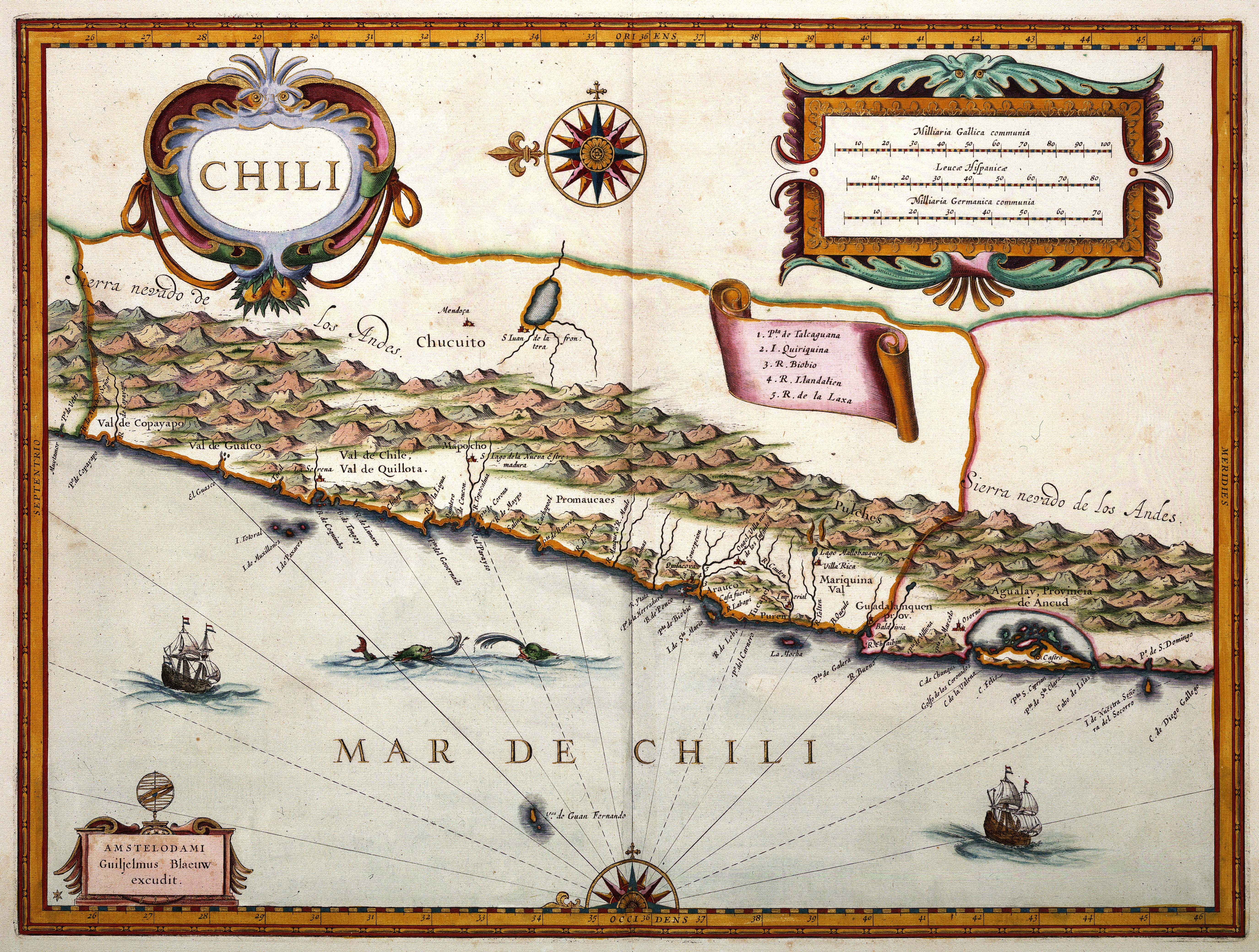
| Title |
CHILI |
||||||||||||||||||||||||||||
| Object type | map | ||||||||||||||||||||||||||||
| Description |
Nederlands:
Willem Jansz. Blaeu (1571-1638) publiceerde deze kaart van Chili in zijn Appendix atlas uit 1630. De gegevens voor het samenstellen van deze kaart, èn alle andere kaarten van Zuid-Amerika in de atlas, nam Blaeu over aan
Joannes de Laets (1583-1649) Beschrijvinghe van West-Indien uit 1625.
English:
Willem Jansz. Blaeu (1571-1638) published this map of Chile in his Appendix atlas in 1630. For this map, Blaeu used information from the "Beschrijvinghe van West-Indien", a famous book by Joannes de Laet (1583-1649) published in 1625. |
||||||||||||||||||||||||||||
| Language |
Dutch
|
||||||||||||||||||||||||||||
| Date | 1630 | ||||||||||||||||||||||||||||
| Publication date |
circa
|
||||||||||||||||||||||||||||
| Medium |
Nederlands:
kopergravure
English:
copper engraving print |
||||||||||||||||||||||||||||
| Dimensions | 36 x 48 cm | ||||||||||||||||||||||||||||
| Collection |
|
||||||||||||||||||||||||||||
| Accession number |
Description of the Atlas Van der Hagen in the catalogue of the KB:
http://opc4.kb.nl/DB=1/TTL=1/LNG=EN/PPN?PPN=353012750 |
||||||||||||||||||||||||||||
| Place of creation |
Netherlands
|
||||||||||||||||||||||||||||
| Notes | KW1049B13_089 - Volume 1 | ||||||||||||||||||||||||||||
| Related persons | Willem Jansz. Blaeu - Joannes de Laet | ||||||||||||||||||||||||||||
| Depicted locations | South-America - Chile | ||||||||||||||||||||||||||||
| References | |||||||||||||||||||||||||||||
| Source/Photographer |
Source page at the Geheugen van Nederland / Memory of the Netherlands website.
|
||||||||||||||||||||||||||||
| Permission ( Reusing this file) |
|
||||||||||||||||||||||||||||


File history
Click on a date/time to view the file as it appeared at that time.
| Date/Time | Thumbnail | Dimensions | User | Comment | |
|---|---|---|---|---|---|
| current | 17:18, 17 July 2015 |
| 5,500 × 4,159 (3.78 MB) | OlafJanssen | GWToolset: Creating mediafile for OlafJanssen. |
File usage
The following pages on the English Wikipedia use this file (pages on other projects are not listed):
- 1925 Chilean coup d'état
- 1973 Chilean coup d'état
- Association of Families of the Detained-Disappeared
- Captaincy General of Chile
- Chilean Civil War of 1829–1830
- Chilean Civil War of 1891
- Chilean War of Independence
- Chilean transition to democracy
- Colonial Chile
- Committee of Cooperation for Peace in Chile
- Conquest of Chile
- Conservative Republic
- Government Junta of Chile (1810)
- History of Chile
- History of Chile during the Parliamentary Era (1891–1925)
- History of the Jews in Chile
- Human rights in Chile
- Incas in Central Chile
- LGBT history in Chile
- Liberal Republic
- List of Chile-related topics
- List of Chilean coups d'état
- List of political scandals in Chile
- List of years in Chile
- Military dictatorship of Chile
- Patria Vieja
- Prehispanic history of Chile
- Presidency of Salvador Allende
- Presidential Republic (1925–1973)
- Radical Governments of Chile
- Reconquest (Chile)
- Royal Governor of Chile
- Tierra del Fuego gold rush
- Timeline of Chilean history
- Timeline of Santiago de Chile
- Vicariate of Solidarity
- User:༆/History of America templates
- Template:History of Chile
Global file usage
The following other wikis use this file:
- Usage on fr.wikipedia.org
- Usage on pt.wikipedia.org